CHIRPS Data Service

The Climate Hazards Group InfraRed Precipitation with Station data (CHIRPS) is a quasi-global rainfall data set. As its title suggests it combines data from real-time observing meteorological stations with infra-red data to estimate precipitation. The data set runs from 1981 to the near present.

CHIRPS incorporates 0.05° resolution satellite imagery with in-situ station data to create gridded rainfall time series for trend analysis and seasonal drought monitoring. Since 1999, U.S. Geological Survey (USGS) and CHG scientists, supported by funding from the U.S. Agency for International Development (USAID), the National Aeronautics and Space Administration (NASA), and the National Oceanic and Atmospheric Administration (NOAA), have been developing techniques for producing rainfall maps, especially where surface data is sparse. The creation of CHIRPS has supported drought monitoring efforts by the USAID Famine Early Warning Systems Network.


There are two main data sets. The first is quasi-global and covers the whole world from 50°N to 50°S. The second covers Africa and parts of the Middle-East. It covers the area from 40°N to 40°S and from 20°W to 55°E. The global data set has data on a 0.05° grid at monthly, pentad and daily times steps. This is equivalent to 31 km2. The ‘Africa’ data set also includes data at a 0.10° grid at a 6-hour time step.

WRA has the complete archive of CHIRPS daily and sub-daily data for 1981-2019, and has developed a software suite to facilitate extraction and analysis for user-defined polygons such as river basins.

WRA provides rainfall data-sets on this basis as a commercial service for clients, and has so far completed CHIRPS projects in Europe, Africa, Middle East and Far East.
Open all Close all
  • Example 1: Tejo River Basin [Spain-Portugal]
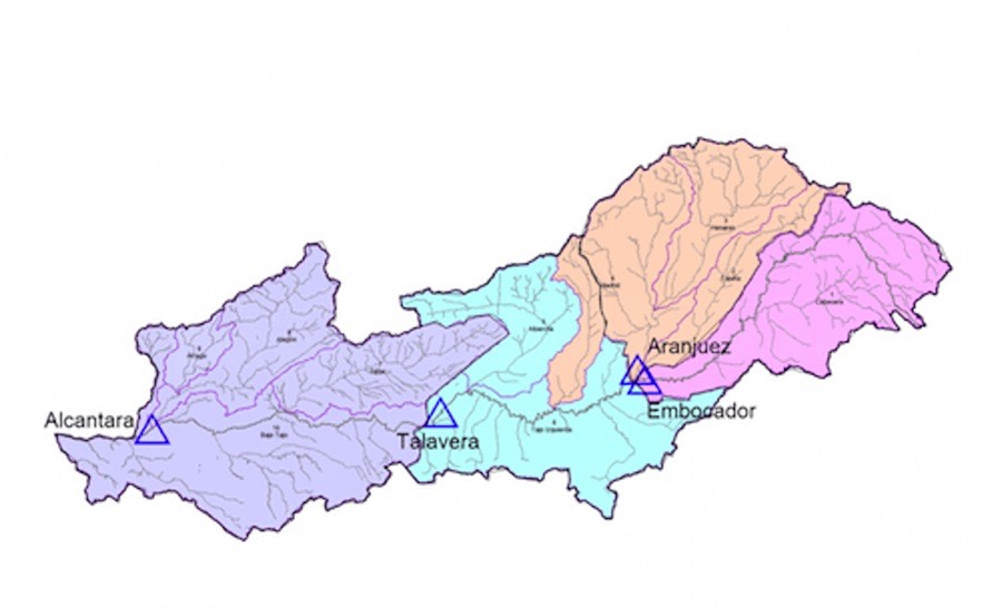
    HYSIM was used to develop a hydrological model of the Rio Tejo catchment [aka Tagus, Tajo] covering 80,100 km2. The objective was to modify the rainfall and climate data to take account of climate change to estimate the impact of climate change on river flows. The river basin is significantly developed with several large dams, mainly for hydropower and irrigation. In fact, no water flows from Spain into Portugal for parts of the year. The capital of Spain, Madrid, lies in the Jarama sub-catchment which is measured at Aranjuez.

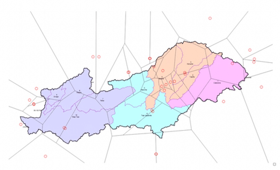
    Rain-gauges are not evenly distributed across the Tejo Basin, so CHIRPS was used to help improve the spatial representation of rainfall in the model.
    Alt image
    chirps-flow-gauging-stations, water-resource-associates

    Location of flow gauging stations

    chirps, water-resource-associates

    Location of rain-gauges

    This map shows the location of rain gauges. There are eighteen rain-gauges in or close to the basin however they are not evenly distributed. There are eight rain-gauges within the Jarama catchment but the other three sub-catchments each have only one rain-gauge within the basin.

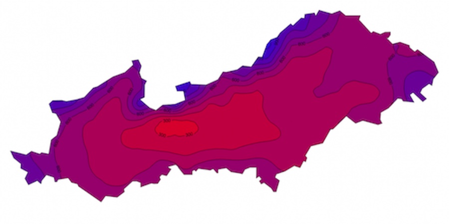
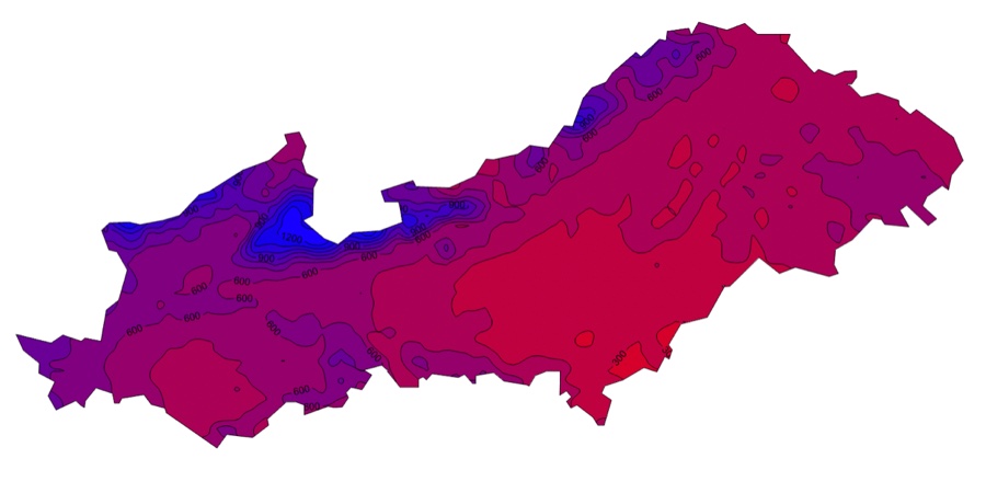
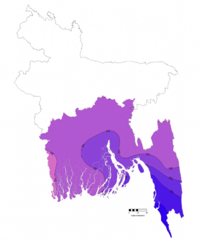
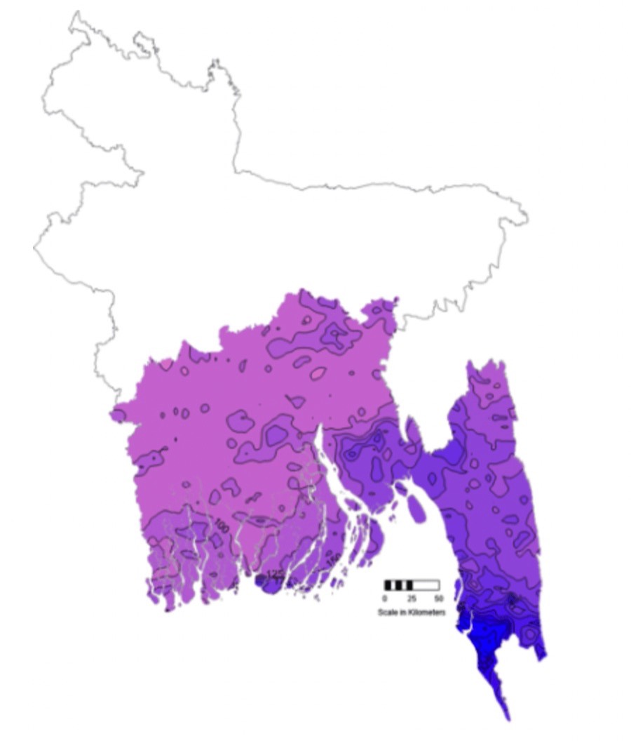
    The next two figures show isohyets of annual average rainfall for the Rio Tejo Basin. The first is based on average values for the period 1961 to 1900 from the Climate Research Unit of the University of East Anglia. The second is based on CHIRPS data for the period 1981 to 2018. There is general agreement on the shape and the value of the Isohyets between the two methods of calculation, despite using different periods and different grid sizes
    Tejo river basin isohyets, cru, water-resource-associates

    Tejo river basin isohyets - Climate Research Unit [CRU] -1961 to 1990

    Tejo river basin Isohyets CHIRPS, wra

    Tejo river basin Isohyets - CHIRPS - 1981 to 2018

  • Example 2: Slovakia
    Slovakia’s northern boundary, with Poland, reaches to 49° 35’ north. This is just inside the northern limits of CHIRPS global version: 50°. This makes it a good test of the validity of CHIRPS close to the limit of its viability.

    The first map for Slovakia shows isohyets of average annual rainfall from the Climatic Research Unit (CRU) and CHIRPS. These show good general agreement except to the west of the country where the CHIRPS data show an area of higher rainfall.
    Alt image
    annual rainfall for Slovakia, CHIRPS, wra

    Isohyets of annual rainfall for Slovakia - CHIRPS 1981-2018

    Alt image
    annual rainfall for Slovakia CRU, wra

    Isohyets of annual rainfall for Slovakia - CRU gridded data 1961-1990

  • Example 3: Southern Bangladesh
    Southern Bangladesh lies at the northern end of the Bay of Bengal. It has India to the west and Myanmar (Burma) to the east. Much of the country is low lying. For much of the southern part of the country the 2 m contour is 100 km from the sea and almost half the country is less 10 m above sea level. Given that the country is subject to monsoons when low pressure increases sea levels, flooding is a major problem.

    Precipitation data were available for 17 station in the study area. However, the quality of the data was generally poor with frequent gaps. This is, in fact, one of the major problems of evaluating CHIRPS; either the data available have already been used by the CHIRPS team for real-time calibration of their product or there is little data for evaluation.

    In this case there were 17 rain-gauges available for evaluation but data were only available from 2000 to 2005. The data had many gaps but an examination of the data did not suggest that the gaps were biased by, for example, having only days of low rainfall with data. It should be noted that the data were downloaded from the TuTiempo web site rather than being provided by government agencies. The following maps shows the equivalent using CHIRPS data. The CHIRPS data have much more granularity. This is not surprising as individual storm cells would produce intense localised rain.
    Alt image
    maximum-rainfall-bangladesh, CRU

    Daily maximum rainfall - 2010 to 2015 – Observed

    Alt image
    daily-maximum-rainfall-bangladesh-chirps. water-resource-associates

    Daily maximum rainfall - 2010 to 2015 - CHIRPS

© 2024 Water Resource Associates LLP | Website by Boray Designs

Privacy Policy Cookie Policy