Caption Text
Link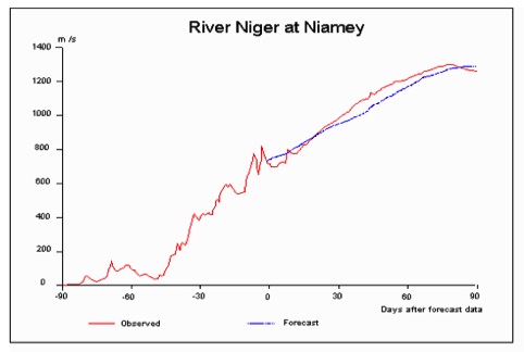

Flooding Guide (Printable)
1. Background
a) The drainage basin
Water flows downhill. If you were to stand on the top of a hill and drop some water just to one side of the highest point, the water would run in one direction; if you were to drop the water to the other side it would flow in the opposite direction. By walking over all the hills around a town subject to flooding you could work out, very laboriously, where the water that flooded the town came from. Fortunately using maps, contour or digital maps, you can get the same information. The total area of land from which water can contribute to the flood is called the drainage basin. The size and shape of the drainage basin are two factors which help to determine the severity of flooding.
b) The flood plain
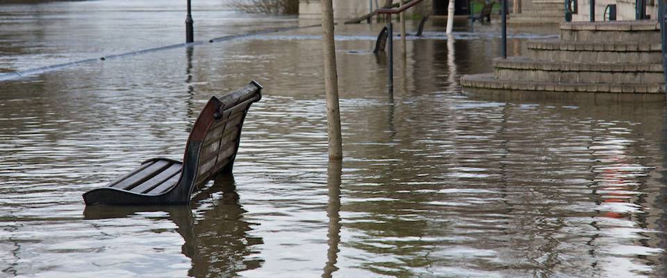
In its natural state a river will over-flow onto land next to the river in most years. This area of flat land is called the flood plain.
c) Flood statistics
The pattern of flooding at a particular town or village is normally described statistically. As an analogy consider the National Lottery in the United Kingdom. Fifty percent of the money staked goes as prizes: one can therefore say the average punter wins 50p for for each pound staked. But this does not make sense as there is no 50p prize. What there is, is a series of prizes of different values and different chances of winning. Most often the £1 stake does not get a prize at all, there is a one in 50 chance of winning a small prize of 10 pounds and a one in several million chance of winning the big prize, the jackpot.
Flooding is bit similar. Most of the time rivers are not in flood, fairly often there is a small flood not large enough to cause significant damage, rarely there is a big flood which cause a lot of damage. And just as the average lottery prize is not very meaningful so it is with rivers. What is meaningful is the pattern of frequent and rare floods. That is why hydrologists will talk about a 1-in10 year, or 1-in-100 year flood; it is a way of quantifying the pattern of flooding.
The analogy should not be taken too far. The chance of winning the lottery is completely random whereas flooding can be, and often is, influenced by man. Another difference is that a draw on Wednesday is not influenced by what happened the previous Saturday - they are independent events. With rivers what has happened over the drainage basin in the days preceding a rain storm can affect the size of any subsequent rain storm. A final difference is that the lottery follows a well defined statistical pattern, that is why the lottery company was able to define the distribution of prizes before a single draw had been made, particularly since they knew they would be dealing with millions of participants so that any random differences would soon even themselves out. With rivers the statistics are built up after several years of observations; the greater the number of years of observations the more accurate the statistics are likely to be. Whilst flood statisticians would like to be able to achieve a similar degree of precision to the lottery this is not really possible - major floods are often caused by an unlikely combination of rare events and over time the pattern of flooding can be altered by the activities of man.
2. Factors naturally affecting the size of a flood
a) The rain storm
It is obvious that this is the main determinant. If there is no rain there is no flood; if there is heavy rain there might be a flood. It is important to appreciate that the type of rainfall also has a bearing. On a largely urban area with a small drainage basin bad flooding may be due to an intense thunder-storm, on a river like the Severn with a large drainage basin it might be due to several days of less intense rain. The weather pattern in the days before a storm can also influence the size of the flood. If rain falls on wet ground it is more likely to produce a flood than if it falls on dry ground.
b) Snow melt
Melting snow can also add to the size of a flood. In some countries, though not the UK, it can be the single major cause of flooding.
c) Drainage basin
i) Size, shape and steepness
As we said above there is a link between the size of a drainage basin and the type of storm which causes flooding. Every drainage basin has a characteristic called the "Time of Concentration". This can be considered as the time it takes for rain from the most distant part of the basin to reach the place where the flood occurs. Generally speaking, a storm which lasts for the same length of time as the time of concentration will produce the worst flood.
The size of the drainage basin is not the only factor. A drainage basin with steep slopes will have a shorter time of concentration than one with shallow slopes. A long thin basin will also have a longer time of concentration than a more compact one.
The time of concentration can vary from less than an hour, for a compact urban basin (a "flash flood"), up to a few days, for a large basin such as the Severn, Trent or Thames.
ii) Geology
A basin with sandy permeable soils will tend to have smaller floods than one with impermeable clay soils.
d) Tides
For places near to the coast at risk from flooding tides can affect flood levels in two ways: Firstly, if flow in a river is an important component of the flood then high tide levels, whether increased by other factors or not, can increase the level in the river and hence the severity of a flood. Secondly, in many places the risk of flooding will come entirely from the sea. Where this is the case the risk would not come simply from a high tide but from one whose levels had been increased by other factors, e.g. wind strength and direction, which can lead to a "funnelling" effect, and low atmospheric pressure. At some sites the worst flooding may occur when high river flows, a high tide, low pressure and strong wind from a particular direction happen to occur at the same time. Some of these factors are independent of each other, a particular combination of the position on the sun and moon which might give rise to a high "natural" would not effect the strength and direction of the wind. On the other hand some factors can be linked, for example low pressure which might cause tide levels to rise can also be associate with heavy prolonged rain. This gives an indication of how complex calculating the statistical likelihood of flooding can be.
3. Factors artificially affecting the size of a flood
a) Land use
As a very general rule the less vegetation there is in the drainage basin, the more severe the flood will be. A basin with heavy tree cover will trap a lot of rain in the leaves of the trees, even grassland will slow down the runoff whereas bare soil will not. Industrial or commercial development with extensive paved areas of roads and vehicle parks, will lead to all the rain becoming runoff and contributing to the flood. Most housing development, with impermeable roofs and roads but with areas of garden and other open spaces, is somewhere between these two extremes.
b) Flood embankments
The effect of flood embankments, or other developments, on the flood plain is one of the most important factors in the pattern of flooding and also one of the least obvious. It may at first seem that building an embankment around a town or village liable to frequent flooding is simply a way of reducing flooding. Locally this is true but downstream the opposite is the case. If development takes place which blocks off all or part of the flood plain the downstream flood peak will be more like the higher upstream peak with, as a consequence, more severe flooding. As an analogy consider a wash basin. If the taps are partly open the drainage pipe can carry all the water easily - just like a river most of the time. If the taps are turned on full and the pipe can't get rid of all the water the wash basin will start to fill up - just like the flood plain. When the taps are turned off the excess drains away again. In this case it is easy to appreciate that the larger the basin, the longer the taps can be full on without the basin overflowing. Similarly with rivers, the more storage there is in the flood plain the less danger of the capacity of the river channel downstream being exceeded.
4. Things which don't affect a flood
This section may seem a bit out of place but it is important to recognise that some things which might be suspected of affecting flood levels generally do not. The first of these is pumping. If a river is used for water resources purposes water may be pumped into it. Not only is it extremely unlikely that pumping of this type would take place during a flood, the rate of pumping would be several orders of magnitude less than that of a major flood.
The operation of sluice gates might have a local effect for a short distance upstream (a few hundred metres at the most) but would have little effect further up or downstream of the gates.
If there is a reservoir upstream of the point of flooding, releases from the reservoir would also be unlikely to affect the size of a flood. Indeed releasing water when a flood was predicted to provide extra storage during the peak of the flood can be an effective way of reducing flooding.
5. Ways of reducing flood damage
a) Flood embankments
These are the most obvious way of protecting property however, as indicated above, they can have a negative impact further down. There may also be other complications, such as getting rid of runoff behind the embankments. It should also be recognised that flood embankments cannot provide protection against any eventuality. A normal standard is against a flood estimated to occur once every hundred years. As is probably clear from the above discussion on statistics it is not always easy to know to a high degree of accuracy what the 1-in-100 year flood is. This however is the solution which has been most often adopted in the past. Were it be adopted in the future great care will have be taken to avoid exacerbating downstream flooding.
b) Channel improvements and diversion channels
Whilst the option of enlarging a river channel, or providing a flood diversion channel, to carry more water seems to be an obvious solution it has a major drawback. The reason for this is due to something called the "regime" of a river. The size of a river is not an accident - it is a function of the pattern of flows in the river and the amount of sediment it carries. Over time the dimensions of a river will reach a state of equilibrium; no erosion will take place in a flood and no sediment will be deposited during periods of flow flow. Whilst natural rivers might have some growth of water weeds in the summer generally they will not become overgrown. Experience has shown that if a river is enlarged beyond its natural size it will soon start to silt up and vegetation may also increase, both of which reduce flow capacity. Similar problems occur with flood diversion channels, these can also be blocked with vegetation (and supermarket trolleys, old mattresses etc!). An additional problem with diversion channels is that suitable land has to be found to construct them and a mechanism devised to allow flow to enter during a flood but not at other times. If either of these solutions are adopted it means that regular, and potentially expensive, maintenance is needed.
c) Upstream storage
It is possible for a reservoir to be built upstream of a town or village liable to be flooded which can be operated in such a way as to absorb much of the flood and only release water at a rate which does not cause flooding downstream. It is, in effect, an artificial way of recreating the benefits of a natural floodplain. This solution is not one that is often adopted. However many reservoirs built primarily for water resources purposes are operated in such a way that they can provide some benefit in relation to downstream flooding.
d) Flood warning
Although this option does nothing to reduce the size of a flood it can be very effective in reducing the cost of damage. If house owners have time to take consumer electronic equipment, carpets and some furniture to an upstairs room it can easily save hundreds or thousands of pounds. For many people their car is their most valuable possession after their house so having time to drive the car to high ground can also save a lot of money.
It has to be recognised that the length of advance warning varies from place to place. We mentioned earlier the "time of concentration" of a river basin. It is not possible to give an accurate forecast further ahead than the time of concentration. This is because flood forecasting is based in part in estimating how soon water in the upper parts of a basin will reach the point where there is flood risk and in part on estimating how much the falling rain will add to the flood. As a result, whilst forecasts of a day or more might be possible at the downstream end of large river basins, the maximum period of forecasts may be less than an hour in small steep basins.
In addition to saving money we must not ignore the saving of lives. Even a short period of warning can enable people to leave areas where flooding is about to take place. Experience, incidentally, has shown that very few deaths during a flood are a direct and unavoidable result of the flood. Some of them are caused by heart attacks due to the shock of flooding or the exertion of trying to move too much in too short a time and others are caused by people taking unnecessary risks.
6. Where to go for more advice
If you are planning a development, the first place, obviously, must be the local planning authority. They will be able to tell you if a particular site is at risk from flooding and what measures might be required both to prevent flooding at a particular site and to prevent flooding upstream or downstream of the site.
The next source of advice is the Environment Agency in England and Wales (EA) or the Scottish Environmental Protection Agency (SEPA). The EA and SEPA have a "Floodline" on 0845 988 1188 which can advise on the risk of flooding at particular site (based on post code). Both agencies have websites with a lot of very useful information on floods including maps of areas at risk of flooding, advance preparations to take if you live a flood prone area and what to do during a flood. The addresses are:
For England and Wales: http://www.environment-agency.gov.uk/homeandleisure/floods/default.aspx
For Scotland: http://www.sepa.org.uk/flooding.aspx